|
健脚向コース マナスル・トレック |
 |
|
健脚向コース マナスル・トレック |
|
|
6.Manaslu Trek |
||||||||||||||||||||||||||||||||||||||||||||||
| ジャパニーズ・ピークとして知られるマナスルの3つのピークを見るトレック。トリスリ・バザールからブディ(ブリ)・ガンダギ川の切り立った大峡谷を通って、対照的な景観のサマへ。雪のラルキャ・ラ(峠)を越え、マルシャンディ・コーラ(川)に下る。 健脚に自信のあるひとにおすすめ。 ロッジ宿泊 |
||||||||||||||||||||||||||||||||||||||||||||||
|
日程 (2023.04 改訂)
|
||||||||||||||||||||||||||||||||||||||||||||||
|
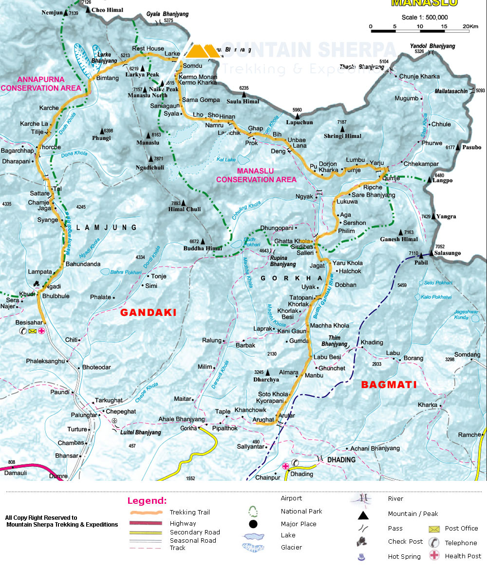
【参考】以下の地図は参考となります。 |
||||||||||||||||||||||||||||||||||||||||||||||
| 料金 お問い合わせ下さい。 2023年よりロッジ泊となります。 (テント泊 フルサービスの場合) 料金に含まれるもの:トレッキング費用(ガイド、ポーター、コック、キッチンボーイ、テント、食事、国立公園使用料、トレッキング許可証、スタッフの保険)、交通費、空港送迎。 カトマンズ宿泊・食事、市内観光、ビザ、アルコール、ソフト・ドリンク、チップの料金は含みません。 |
||||||||||||||||||||||||||||||||||||||||||||||
| Back to 健脚向 | ||||||||||||||||||||||||||||||||||||||||||||||
Back to
HIMALAYAN SHERPA ADVENTURE (P.) LTD
P. Box No. 4550 Chabahill, Kathmandu, Nepal
Phone: 471549/480064 Fax: 977-1-480806
2016.08
Day 1.Arrive Kathmandu.
Day 2. Kathmandu
Day 3. Drive to Arughat (570m) - 7 hours driving.
Day 4. Trek to Soti Khola (730m) - 5 to 6 hours walking.
Day 5. Trek to Macha Khola (930m) - 6 to 8 hours walking.
Day 6. Trek to Jagat (1,440m) - 6 to 8 hours walking.
Day 7. Trek to Deng (1,860m) - 7 hours walking.
Day 8. Trek to Namrung (2,540m) - 7 hours walking.
Day 9. Trek to Lho (3,020m) - 4 hours walking.
Day 10. Trek to Samagaon (3,450m) - 4 hours walking.
Day 11.Acclimatisation day at Samagaon (3,450m).
Day 12. Trek to Samdo (3,860m) - 3 hours walking.
Day 13.Rest and acclimatisation day at Samdo (3,860m).
Day 14. Trek to Larkya Phedi (4,460m) - 3 to 4 hours walking.
Day 15. Cross the Larkya La (5,135m), trek to Bimtang (3,590m) - 7 to 8 hours walking.
Day 16. Trek to Dharapani (1,860m)-7 to 8 hours walking.
Day 17. Trek to Jagat (1,430m)- 6 hours walking
Day 18. Transfer to Besisahar then by private transfer back to Kathmandu.
Day 19. Fly back home
Manaslu
Trek : Crossing Larkya La Pass - 19 Days
MANASLU CIRCUIT
Day 1.Arrive Kathmandu.
You will be met on arrival at Kathmandu airport and driven to
the hotel. A trek briefing will be given in the afternoon.
Overnight
at hotel
Day 2. Sightseeing in Kathmandu of free day in Kathmandu as
per the choice of the clients
This is a day to explore
Kathmandu where we organise guided sightseeing to the Buddhist and Hindu sights
in Kathmandu, to Kathmandu’s Durbar Square, Swayambunath - the Buddhist monkey
temple and Pashupatinath – a sacred Hindu temple complex on the banks of the
Bagmati River.
You should get back to the
hotel after your sightseeing tour around mid afternoon and the rest of the day
is free for you to explore the city further and pack bags ready for the start
of the trek the following morning. You can leave a bag at the hotel with items
you will not need on the trek. Overnight at hotel (B)
Day 3. Drive to Arughat (570m) - 7 hours driving.
Overnight at hotel (B,L,D)
Day 4. Trek to Soti Khola (730m) - 5 to 6 hours walking.
Our route heads northwards
following the Buri Gandaki river, passing through terraced fields and scattered
farmhouses. After climbing briefly to Keurenipani, we descend once again to the
river and to Soti Khola.Overnight at teahouse lodge
(B,L,D)
Day 5. Trek to Macha Khola (930m) - 6 to 8 hours walking.
The trail crosses a bridge
and climbs to the ridge above huge rapids in the Buri Gandaki and continues to
Korsani. The trail now gets a bit more challenging as it climbs over a large
rock and crosses a stream on a single log bridge then weaves its way up and
down again to the banks of the Buri Gandaki. It continues up a steep rocky
trail to the Gurung village of Labishe. From Dobhan it climbs behind a rocky
outcrop to an old school from where the valley widens, then the trail drops to
a high waterfall with a wooden bridge. The trail climbs over another ridge and
descends to the sandy
riverbed. There is a short walk before a climb to avoid a spot where the river
has eroded the original trail, and after a short descent there is another climb
to a ridge then a traverse to the village at Macha Khola.
Overnight at teahouse lodge (B,L,D)
Day 6. Trek to Jagat (1,440m) - 6 to 8 hours walking.
From Korlabesi there is a steep ascent to a ridge then
down to a hot spring and a stone structure that marks Tatopani. After crossing
a suspension bridge over the Buri Gandaki the trail climbs some stone stairs to
Dobhan. The trail gets quite rugged and starts by climbing to two teashops at
Duman, then crosses a landslide area and after some ups and downs through
ravines it reaches a large field. After crossing a suspension bridge the trail
ascends a set of stone stairs, drops to the river and ascends once again to
Thado Bharyang. Once over the river, the trail continues for a while before
climbing to Jagat.
Overnight at teahouse lodge (B,L,D)
Day 7. Trek to Deng (1,860m)
- 7 hours walking.
There are good views of
Shringi Himal as you walk along the side of a cliff. The trail descends to
Setibas where the mani walls (prayers engraved into wayside rocks) show that we
are entering a region with increasing Tibetan influence. Beyond Serson the
trails enters a steep gorge and descends through grassy slopes, dotted with
pine, to cross a cantilever wooden bridge at the river's narrowest point; below
you will see the confluence of the Shar Khola and Buri Gandaki rivers. The
village of Nyak is located close to here. The trail makes its way up the west
side as the valley and offers a pleasant walk through bamboo forests to Deng
Khola and the village of Deng. Overnight at teahouse lodge (B,L,D)
Day 8. Trek to Namrung (2,540m) - 7 hours walking.
A short distance out of
Deng, the trail crosses back over the Buri Gandaki onto what is now its north
bank near Rana. From the bridge the trail climbs a little before heading west
on level ground and passing a large waterfall. Once over a wooden bridge, the
trail contours up and out of the canyon and climbs high above the river before
dropping into the Shringi Khola Valley.
Back on the south bank, the
trail makes a long climb through bamboo and rhodhodenron and finally enters
Namrung (or Namdru) through a stone archway. Overnight at teahouse lodge
(B,L,D)
Day 9. Trek to Lho (3,020m) - 4 hours
walking.
Today is a shorter day as
we need to limit our increases in altitude in order to have time to
acclimatise. Not long after leaving Namrun we arrive atBanjam with its wide
fields. Soon after Banjam the trail gets steeper as we walk up to the next
village of Lihi with a fine view of Ganesh Himal. A further hour along the
trail we arrive at Sho and then followed by another hour at Lho. From this
village there are fine views of Manaslu and the Kutang Himal. In the afternoon
it would be worth visiting Ribang Gompa overlooking the village as well as
exploring the stupas, mani walls and kani gateway.
Overnight at teahouse lodge (B,L,D)
Day 10. Trek to Samagaon (3,450m) - 4 hours walking.
The trail crosses the ridge
onto the Buri Gandaki Valley side and then descends to a rock strewn moraine.
After crossing some boulders, the trail emerges onto the extensive pastures and
fields near Sama gompa. There is a lot to explore, it is a little piece of
Tibet with many gompas and a traditional Tibetan village. Overnight at
teahouse lodge (B,L,D)
Day 11.Acclimatisation day at Samagaon (3,450m).
We spend two nights at
Samagaon to help acclimatisation. There is a worthwhile day’s walk to the Pung
Gyen monastery which has superb views of Manaslu and Peak 29. Overnight at
teahouse lodge (B,L,D)
Day 12. Trek to Samdo (3,860m) - 3 hours walking.
Follow the Buri Gandaki
northwards to a bridge over a side stream where the trail forks: the left
leading towards the Manaslu Base Camp, the other passing several mani walls,
heads for the Larkya La. The valley widens along an easy trail past juniper and
birch forest to the stone huts at Kermo Kharka, then drops off a shelf to cross
a wooden bridge and climbing between a fork in the river to a promontory. From
this vantage point, one can see the white stone kani marking the entrance to
Samdo. Overnight at teahouse lodge (B,L,D)
Day 13.Rest and acclimatisation day at Samdo (3,860m).
We spend two nights at
Samdo to help acclimatisation. There is a good walk towards Gya La which is the
trading pass with Tibet. Overnight at teahouse lodge (B,L,D)
Day 14. Trek to Larkya Phedi (4,460m) - 3 to 4 hours walking.
Today we start the ascent
to the pass by descending through fields to an old mani wall and stone arch
before dropping to the river and crossing on a wooden bridge. This place shows
up on maps as the mythical Larka Bazaar, which used to be a flourishing market,
but there is nothing remaining there now. Another mani wall marks the beginning
of ascent to the pass where the trail starts climbing through tundra and
juniper; the huge Larkya Glacier coming from Manaslu can be seen from here.
Nearing the Larkya Glacier, we reach Larkya Phedi, where there is a small
lodge, built to serve travellers crossing the Larkya La which lies now just
ahead. Overnight at teahouse lodge (B,L,D)
Day 15. Cross the Larkya La (5,135m), trek to Bimtang (3,590m)
- 7 to 8 hours walking.
The trail starts as a long
gentle climb across moraine, it descends a little to a lake and then becomes
rough and indistinct as it crosses to the south of steep grassy slopes. Descend
to the four frozen lakes then make the final steep climb to the pass. On the
descent from the pass the trail follows the top of the moraine to the west and
makes a set of steep, rough switchbacks as it crosses the moraine then descends
more gently on loose gravel
to another grassy moraine
at 4,450m. The trail now becomes easier to follow and reaches a small meadow
and spring at 4,080m. The valley becomes wider as the trails heads down to a
large meadow, past a mani wall and a small rest house that marks Bimthang at
3,590m. Overnight at teahouse lodge (B,L,D)
Day 16. Trek to Dharapani (1,860m)-7 to 8 hours walking.
The trail drops to a
glacial stream, the headwaters of the Dudh Khola, and crosses a wooden bridge
and descends into pine and rhododendron forest to Hompuk at 3,430m. The trail
improves as it descends to a fork in the river and then follows the river to a
stable at 3030m. Not far from here you reach Karche's fenced fields, then cross
a landslide before making a steep climb to a ridge decorated with prayer flags.
It makes a descent to the river bank at Gho. The trail continues through fields
and intermittent stands of rhododendron and oak to arrive at Tilje, a large
Gurung
village. The walls of the Marsyangdi Valley loom larger and
finally the houses of Dharapani appear in the distance.
Overnight at teahouse lodge (B,L,D)
Day
17. Trek to Jagat (1,430m)- 6 hours walking.
From Dharapani you are now
on the more popular Annapurna Circuit and the trail now follows this classic
trek in reverse as you pass through the steepest part of the Marsyangdi gorge.
Our trek ends in Jagat as it is now possible to take jeeps from this village
along the road to Besishar. Overnight at hotel (B,L,D)
Day 18. Transfer to Besisahar then by private transfer back to
Kathmandu.
Rest of the day at leisure.Overnight at hotel (B)
Day 19. Fly back home
Transfer to the airport / Farewell
Back To
ヒマラヤン・シェルパ・アドベンチャー